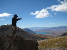
 Park" because it was actually labeled with this title back in the 19th century and was only the second place, after Yellowstone, to be given this designation. Tongariro is one of the "must-see" spots on the north island as the Tongariro Alpine Crossing is walked here and it is considered the best one-day walk in the country. It is about 18.5 km (a little over 11 miles) and took me and a group of five others about 6.5 hours to do with a lunch break and some occasional stops. We did this walk two days ago and it was truly amazing. The landscape changed about 5 times and every time we turned around a bend or got to the peak of a rocky path we were climbing, the scenery changed once more. I will post a bunch of pictures below to give you all an idea and how the trail changed so drastically at each segment (Note: You can actually click on the pictures and it should give you the full version of them).
  At the peak, we were about 1,900 m up, which was a bit short of Mt. Ruapehu at 2,800 m (tallest in the north island) and Mt. Nguaruhoe, which as I mentioned previously, is actually Mt. Doom in Lord of the Rings, at 2,300 m and has a perfect conical top in it. Our guide told us this volcano is also used often as a "stunt double" for Mt. Fuji in Japan as there is no development or towns around it - it was also used in Last Samurai in this respect.
 small bodies of water that were a bright green with a yellowish tint, which most likely was due to the abundance of sulphur from under the ground. Again, the landscape changed back to very baron looking walls of brown and red mountains with very rocky paths. Shortly thereafter, the scenery changed dramatically and all around us were tall, wispy yellow, knee-high plants and it was almost as if we were transported to the English countryside. This continued for a while and weaved in and out of some streams, an occasional waterfall, and several sulphuric gas vents in the ground. This whole segment was also ancient burial ground for the Maori people and you were not allowed to step off of the trail. The alpine flowers, tall, yellow plants continued to surround me until I finally reached the forest canopy towards the bottom of the trail and for the last segment was immediately welcomed into a lush forest with trails covered in trees and moss and rapidly flowing streams to the left of me. When we finally made it to the end of the trail, a simple car park was there and everyone coming through to the end showed visible signs of exhaustion, joy, and amazement at the fete just accomplished. It was not very difficult as long as you were fit, but it was very long for a day hike and many people actually do the whole circuit over a span of 4 days.
So, I hope this post did not bore you, but I felt like it deserved its own story as it truly was an  amazing day of tramping through authentic Kiwi national park. I ended up staying at the National Park and the Lodge here for 2 extra nights as it is so comfortable here, the views of the summits are right outside the cafe (see closest picture), and it was a great place to relax before I continue on to Wellington and then take the ferry over to start my adventures on the south island. It amazes me every day to think that I've only been traveling down from Auckland for a little over a week and yet feel like I have been exploring the north island for much longer. I am very excited to see what the south island brings, as it is supposed to be even more wilderness, with many glaciers, the Southern Alps mountain range, pristine beaches, Marlborough vineyards, etc.
Talk soon,
Justin
Wow
ReplyDeleteYou took me right there on your trip with you.
I could feel like hiking there with you
Have a great time on the south island
snow and rain last 2 days here, and a lot of grey gloominess , normal for winter here. Not missing anything here
Sounds beyong amazing dude, can't believe you did 11 miles. Can't wait to see all the pics.
ReplyDelete