 This picture is of Mt. Cook, which is the largest peak in NZ at 3,754 m. (it's Maori name is Aoraki and literally means "Cloud Piercer") I think it is a fitting way of starting this post that describes the 11-day hike I just finished yesterday as I think it was one of the more memorable pictures in my mind from the trip. In total, I hiked 81 km, cycled 47 km, and kayaked 14 km. Sorry that this is in metric, but over here they won't even listen to you if you try asking for things in miles, feet, etc. The group was 10 people including myself and a Kiwi guide. The others were from Sweden, Finland, France, the UK, and I was representing the ol' Red, White, and Blue. I'll try and summarize everything I saw, experienced, hiked, etc. and give more pictures as it's probably a better way of showing you all the incredible landscapes I was surrounded by each day. The first day of the trip we all met in the center of Queenstown, did some introductions and quickly did our first grocery stop and some other administrative items, including job designation. I was given the easy job of telling people what meal/clean-up duty they were on each day and simply carried around a sheet of paper with the whole grid, which people dreaded each time I took out because they may be the next name to be called to clean up dirty dishes in frigid water in the dark while camping...
Our first hike (6 km) was to the Key Summit on the renowned Routeburn Track in the Fiordland National Park. This park, as well as 3 others all connected in the South Island, are World Heritage Sites, and make up around 20% of the land mass of all of NZ;
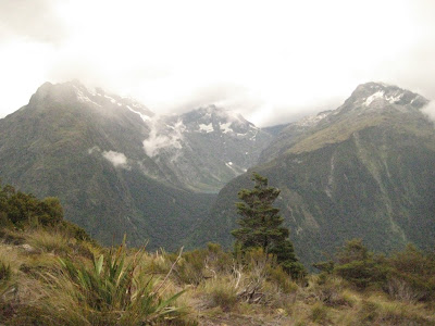 which means that much of the country is protected for the world under this label, which is pretty crazy to think. We had great views of the Darran Mountains, which you can see in the picture, and saw clouds actually being formed in front of us, rare alpine flowers, and some hanging valleys like the one shown here. These valleys were formed when two glaciers were connected, one carved out the valley and went through, and the other on top melted, leaving a valley "hanging" between the mountain with a glacial lake in it. We stayed at a cool little place called Gunn's Camp and had really basic accommodations in old miner shacks, but the novelty of it was an experience for me and our group started bonding that night over corny, yet effective, ice-breaker activities. The second day we
  woke up early and most of us went to the kayaking shed next to Milford Sound, got on a bunch of thermals and jackets on (as cold temperatures and rain was an inevitability) while avoiding the onslaught by local sand flies - basically vicious little buggers that bite the crap out of you - and then got into our 2-person kayaks. The total for the day was about 14 km kayaking, and was pretty challenging at first for me as I have only kayaked once or twice, and never with rain pouring down, decent waves and wakes from boats, and high wind. But the views were some of the best I've seen in the country as there are massive land masses jutting out of the sea and clouds hovering all over at low altitudes, with skyscraper-tall waterfalls cascading off these mountainous bodies, and also fur seals swimming all around (saw one that was apparently digesting his food by swimming back and forth along the rocky shore)
  The day was long and tiring, but well worth it, and we slept at a nice, local campsite. The views here for the sunset were spectacular as some of the ash from the deadly fires in Victoria, Australia were mixing with the air all the way over in NZ and made the sky look like it was on fire (see adjacent picture). The next day we packed for our first overnight hike and I finally experienced what true hiking/tramping was, as I now had a 15 kilo bag on my back instead of the light day bag. But my body and feet soon got used to the extra weight. We made our way up to the Borland Saddle (1000 m) and had some amazing views of the landscape, but very different again from the previous day. It was a lot of tussocky terrain with small ponds here and there, great views of the Fiordland National Park in the distance, and the ever-present, low-lying clouds moving quickly over the ranges and making superb photo opportunities.
Eventually we made our way to the hut we were staying at (the Department of Conservation, similar to our Forestry Service, but massive in size and well-known/respected by the whole country, maintains huts along a lot of their popular paths for trampers (hikers) to use to sleep in) along the Green Lake and made a good pasta with bacon dinner on the burners we carried with us in our bags. It was a great first experience and toe in the water to test out my foray into hiking, camping, basic cooking, close quarters. And that night we did another group game called "Can you do this?" where each person thought of a challenge for the whole group to try and pull off. Mine was a one-arm push-up (which, yes, I did successfully), but the best was Roger's (older guy from the UK) challenge of trying to make it around the whole hut without having your feet hit the ground (see picture of this 6-foot guy attempting the fete).

This finished off Tuesday, our third day hiking, and adding another 10 km to the mental odometer. The following morning we packed up our bags and headed out to hike another 13.5 km through some beech forest and more tussocky basins. I was very tired after these two days as you never really get good sleep while in the huts or camping in tents, as I quickly discovered on this trip. I basically woke up a couple times each night, whether it was due to being too cold, too hot, not being able to move my legs in the mummy-designed sleeping bag, or others snoring. I didn't mind though as I expected it and knew the next day I would be hiking through amazing scenery and this was a small price to pay. We wrapped up the hike, put our bags in the trailer and drove down to the Caitlans Coast, which is renowned for its hector dolphins, yellow-eyed penguins (3rd largest in the world and endangered), massive sea lions, and seals. This area of the country was some of my favorite as there were massive sheep stations mixed in with rolling countryside and beautiful coastal views; knowing that 5,000 miles away on the other side of the water was Antarctica  was a cool thought as well. We went through Invercargill and stayed at a cosy crib (NZ summerhouse where a lot of surfers stayed) right on Curio Bay. The next day we did about 5 different shorter walks that totaled 6 km, but was a great rest on our feet and we were able to see the dolphins in Curio Bay, a fossilized forest from 180 million years ago, Surat and Cannibal Bays with the great, beastly-looking male sea lions (bulls), and several yellow-eyed penguins later that night. The penguins were in a cove located on a private farm we were able to go on through the hiking company's contacts and it was awesome to see
  them swim up from the waves, waddle on to the land, and slowly traverse the grassy hills to go feed their newborn young. And we actually got to see a penguin and it's gray baby coming down the hill at one point. After this we came back to where we were camping and finished making our "hangi" dinner, which is a Maori was of cooking meat and vegetables where you basically dig up a large ditch, get a tepee of fire going, then get the fire to start heating a certain type of stone, put the meat/vegetables in a cage covered with a special cloth, bury this cage on top of the burning hot stones, and then dig up the dirt 2 hours later and you will have great, smokey-tasting food, somehow cooked to perfection without any temperature regulator or timer. We had lamb, chicken, kumara (sweet potato), pumpkin, corn, potatoes, and carrots and they all tasted absolutely delicious.
Friday, Day 6 was our "rest day", but a group of 5 of us decided to do the 47 km section Otago Central Rail Trail. This trail is over 100 km in total and used to be an old railway line that was built in the early 1900's to connect Dunedin (the main city/town in the area) with the other small towns westward to ship livestock and also for people hopping around looking for gold after the first discovery of the rock a bit earlier. The cycling was a lot of fun and we rode through some amazing landscapes once again, changing from tunnels, viaducts, canyon-walled tracks, vast sheep and deer paddocks, and rolling and moundy hills in the distance. The cycling became pretty challenging after we stopped after 30 km and had our break of pints of Speights ("The Pride of the South"). Let's just say that the last 17 km was pretty tough on the legs and I was glad when we could put our bikes away and have our first meal at a restaurant in the bustling metropolis of Alexandra (population: 2400).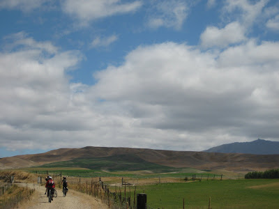

Days 7 and 8 were our second overnight hike (24 km total) and were around the Ohau Range and near some spectacular scenery with Lake Ohau in the foreground and some of Mt. Cook National Park and it's snow-capped peaks all the way in the background. These two days were also challenging hiking as there were a lot of steep inclines, especially up through the rocky bowls near the top of the Ohau Range (1915 m). It was a lot of fun though setting up our tents right along the Freehold Creek and being able to doze off to the sound of the water rushing along the rocks and then wake up in the freezing cold, hurrying to put some clothes back on. And it really was unique to live my days at the mercy of the sun and try and cram everything in (cooking, writing, setting up the fire, etc.) before darkness came. We also encountered some wild horses along the way, which made for some great photos with Mt. Cook and other mountains the background (again, very Lord of the Rings as many places and scenery seemed like). On Day 9 (Monday) we drove over to Mt. Cook National Park and did an 8 km day hike to get views of this monstrous mountain that many Kiwis and foreigners have perished trying to climb. Our guide, Kaz, commented in a very serious way that, "You don't conquer the mountain, it simply lets you climb it." Telling us this next to the Alpine Memorial, which had memorials up for many climbers who lost their lives climbing the nearby peaks, was a bit morose, but pretty appropriate. As you can see from the first picture of the post and the one below of Mt. Sefton (3100 m), this park had some amazing scenery and actually was home to 19 of the 27 peaks in NZ that were over 3,000 meters.
We camped by the shores of Lake Pukaki and I was in charge, with Alice's help, to make a chicken satay with vegetables and rice, which was pretty challenging given the equipment (lack thereof) to make the meal, a setting sun, and a wind blowing fiercely into the trailer, blowing out the gas every 5 minutes. At one point, the chicken was still raw, the satay looked like a liquidy dog food, and Alice had severed her finger while cutting carrots as Anders distracted her, probably humorously asking her something about France after asking me about the different football teams what were being referenced in his copy of The World According to Garp. Needless to say, Viki was able to save the day using her innate cooking skills, and the meal come out really  well and eaten just before sunset as I set up the ipod speakers to play some tunes (Radiohead and then Miles Davis, bit of a weird mix, but it worked). The final two days went by pretty quickly as we hiked 7 km around the Mackenzie Basin and Mt. Somers on Day 10 and stayed at a very nice hut that Kaz's father-in-law actually helped build as part of the DOC (it seems that a lot of Kiwis have had a hand in helping build or preserve their land). Some people went swimming in the brutally-cold waterfall, while I simply did an ad-hoc "shower" in the creek right outside the entrance to the hut. The next morning we started our last day of hiking checking our the water caves, which were giant boulders that had fallen on each other over streams, forming small caves that you could walk through (Carefully) and also swim if it was a nice day. It was pretty cloudy and misty so our group just walked around and took some photos. We came back to the hut to grab our bags and then set off for the 6 km hike back to the van to end the trip. It ended up being a bit longer than that as we got lost along the way. We had to detour from the parts of bush as there was a certain tree that wasps swarmed to and Anders was allergic to bees. This detour brought us to many places surrounded by Scottish gorse, which was introduced by them when they came over to NZ as good hedging plants, but grew completely out of control and were like little daggers into your skin as you brushed past them (See the up-close shot I took of them after these little bastards tore up my legs). We eventually made our way back thanks to Roger's
  GPS device and exasperated, flung our bags to the ground and tried to rest, but were immediately met by some wasps and hoards of sand flies and had to pack up quickly and move elsewhere to pack up our gear to end the trip. We drove back, most of the group sleeping, and came into Christchurch to drop everybody off at their respective hostels. I'm staying at the Jailhouse Accommodations right now, which was actually a Dept. of Corrections prison built in the 1880's and recently turned into a brand new hostel. It's really clean, pretty unique, and has a massive amount of DVDs, of which I used this morning to revive myself with The Dude's help. All of us (except for Roger & Anne, who made their way to Hanmer Springs to go to a spa for a couple days) met out at a real good British place for dinner and I had a delicious Murphy's Steak & Stout pie, which really hit the spot.
Overall the trip could not have been more of a success. I met some amazing people (of which I hope to connect with again on a future Europe adventure), saw great scenery and wildlife, became decently skilled at living in the outdoors with basic tools for cooking and sleeping, and did some major exercise in the span of only 11-days. I will now be in Christchurch until Monday morning, when I fly over to Melbourne and start my adventures in Oz, which I'm very excited about as well. I hope all of you are well and I shall be connecting with you soon from Australia.
Justin


